030 Lusatian Mountains From Marenice to Elephant Rocks 1. 12. 2018
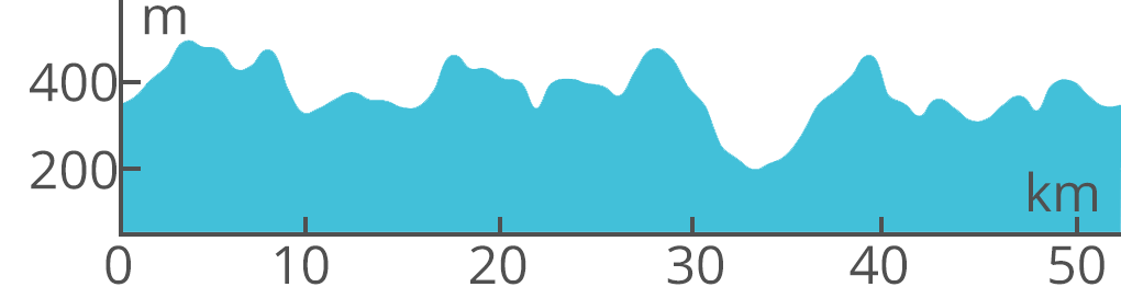
The hilly country with dense, lonely forests is interwoven with many natural-pathways. In addition to the peaks of volcanic origin, the sandstone rocks
of decorative shapes encircle the landscape. Elephant rocks are like a herd of grazing elephants, and from Pop's Rock there is the beautiful view of the
Central Bohemian Highlands, the Jizera Mountains and the Giant Mountains. And also on the harsher and higher part of the Lusatian Mountains, which we
will pass next.
Points of interest
Mařenice - The Church of St. Mary Magdalene, Sokol Hill - ruins of the Old Falkenburk castle, Rock formation of Havran in Polesí (viewpoint),
Elephant Stones - a cluster of sandstone rocks, reminiscent of a herd of elephants, Vraní skála (Crow Rock) - climbing terrain, Popova skala - view of the Lusatian
and Jizera Mountains, Giant Mountains, Ještěd and Central Bohemian Uplands, Czech Gate - sandstone rock formation, Loupežnický vrch - castle ruins Větrov,
ridge from Mařenice to Elephant Stones - continuous zone of fortifications ŘOP
Route:
From Mařenice follow blue and then go along red to Petrovice, blue to Polesí, along the unmarked way upstream to the creek to the north to the green, green
to the crossroads Pekařův kříž (Baker's Cross), along an unmarked forest road parallel to the green downhill to Horní Sedlo, along the road to Horní Sedlo,
in front of the village turn right and down the hill along the unmarked forest path to the Elephant Stones, along the same way back and through Horní Sedlo to the red
to the crossroads Krásný důl (Beautiful Mine), green and blue to Popova skála, along blue, unmarked, green and again blue downhill to Hrádek nad Nisou, along the green
through the valley of the White Creek around the Czech Gate to the crossroads Close to Tobiáš Pine, along the red to Petrovice, on an unmarked road to the south
on a 241M cycling trail, 900 m on the road to the west, along the blue 960 m to the north, along the forest path to the SS on a cycling route "To the neighbors",
along the forest road, take the northern slope of the Chateau Hill, along the way "To the neighbors" to Mařenice
 The hilly country with dense, lonely forests is interwoven with many natural-pathways. In addition to the peaks of volcanic origin, the sandstone rocks
of decorative shapes encircle the landscape. Elephant rocks are like a herd of grazing elephants, and from Pop's Rock there is the beautiful view of the
Central Bohemian Highlands, the Jizera Mountains and the Giant Mountains. And also on the harsher and higher part of the Lusatian Mountains, which we
will pass next.
The hilly country with dense, lonely forests is interwoven with many natural-pathways. In addition to the peaks of volcanic origin, the sandstone rocks
of decorative shapes encircle the landscape. Elephant rocks are like a herd of grazing elephants, and from Pop's Rock there is the beautiful view of the
Central Bohemian Highlands, the Jizera Mountains and the Giant Mountains. And also on the harsher and higher part of the Lusatian Mountains, which we
will pass next. Lenght: 52 km