019 – Džbán (Jug) Over the table-topped mountains in the mysterious region 1. 1. 2018
The abandoned landscape northwest of Prague reminds of the Lost World with table-topped mountains. The dinosaurs, unlike Doyle's novel,
do not live here, but the trace of prehistoric people and our recent ancestors has been found here. From the older stone age comes the
finding of a stone chopper from Mutějovice, the unknown age is the head of the celtic warrior and the mysterious Nečice and Kounov
stone rows. On the flat hills there are remains of fortified villages, inhabited for thousands of years, and medieval villages
with stone houses from the local opoka are hidden in the valleys. And cyclists do not touch a living soul in dense forests all day long.
The film is in Czech with English subtitles
Džbán Nature Park
was declared on May 1, 1994. There are many protected plants and animals, the area is also interesting from a geomorphological point of view.
An area that almost no one from Prague knows lies between Žatec and Kladno. It is made up of a complex of hills with extensive plateaus, among
which there are many broad valleys. The area is a raised edge of the Bohemian Cretaceous Basin. Its surface is protected by a horizontal layer
of hard opoka stone, that resists weathering. That is why the surface of the local hills is flat. Beneath the opaque layer are already much softer
Cretaceum sediments and Carboniferum-Permium sandstone and claystone. Along the breaks, there was extensive erosion that shaped the wide valleys,
separating the isolated mountain table. The addition of iron oxides in claystones causes a typical reddish color of the soil. There are two
competitors in the struggle of the highest peak of Džbán - Louštín and Džbán hills. Džbán is 536 m above sea level, Louštín 535 or 537 m nm. So choose.
Opoka, which is mined here today, was a building material used in the Middle Ages. Thanks to its golden color, Prague got the nickname "golden."
But it was not used only to build magnificent buildings in big cities. Virtually all houses in the local villages, more than a hundred years old,
are also built from opoka. Nowadays many homes are crumbled. The region seems to be poor and the tourism does not help, because only few people
come here. The hop from Džbán this region is famous, the hop fields are among the forest hills wherever the eye can see. The problem is with
refreshments along the way. It's hard to hit an open pub, for example, the one in Zbrašín, where we are going, is for sale at the moment.
Therefore, it will be better if you take your meal for the whole day.
People have lived here since the Stone Age, as evidenced by the 250,000-year-old fist-wedge from Mutějovice. After the Celts,
the head and the mysterious Nečice and Kounov stone rows remained. The Slavs on the Jug warred with the tribe of Lucians and, as
one of the few legends from Jirásek's Old Czech legends, the War of Lucko was based on the actual events described by the chronicler
Kosmas. The flat hillocks attracted our ancestors to build the fortifications, such as the fortifications Okrouhlík (Hřivické), Kuk (Výrov),
Rovina, Louštín and Dřevíč, the fortress Hrádek and Rychvald and castles Kozí Hrádek, Pravda (True) and Džbán (Jug).
On the first table mountain
We decided start in Zbrašín. The village was probably built in the 14th century and it is surrounded by hop fields. From the nice
village, we will climb along the field and forest path along the blue tourist sign to Okrouhlík hill. The climb is pleasant, and it can
be practically ridden by bike. At the top there is a complete plain, after which a blue and then green sign leads us to fortification
Okrouhlík (Hřivice). Do not expect to see something interesting besides the elongated hillside, which is the remains of a wall and a
parallel trench. It's too old for that. It comes from the Middle Bronze Age, later it was rebuilt by the Slavs. The road leads back
to the blue sign. From the edge of the platform just before descending to Konětopy there is a nice scenic view of the wide valley and the Výrov hill.
Restaurant Pod Borem
The steep descent to Konětopy is the most beautiful downhill of today. The first part is going along a wide path through a beech
forest and then along a narrow sandy pine forest path. Konětopy are also from the 14th century, like most of the nearby villages.
Local residents do not have the money to repair old stone houses, and it looks like the Allied bombing in the village. The previously
famous Pod Borem inn, where the giant arrow on the gleaming walls of one of the largest local houses shows, is open only occasionally.
Even in 2005, the article was published in the local newspaper "Free Voice": "Not only the locals but also the tourists and mushroom pickers
have bold underlined traditional rural pub in the village of Konětopy in the imaginary map of beer refreshments. It is the innkeeper, who in
its long-term work impresses its pubs with a specific atmosphere and name. This is the case of Konětopy inn, where the golden blessing Luboš
Verner is serving for the fifteenth year ... "The free voice at the end of 2016 went bankrupt after 25 years, and there is no longer Mr. Verner.
If it is closed, you do not have to despair. In the vicinity of the pub, there is a Vietnamese shop, which is surrounded with locals with beer bottles.
Time is changing.
On the second table mountain
Along the red mark on a stony field road, we climb from the railway station. From the meadow above the village there is a nice look back
to Okrouhlík and to the north on the lone hills of the Central Bohemian Mountains and the ridge of the Ore Mountains. We will pass the pasture
and go to the woods where we will stop at St. Peter and Paul statuettes. It is the creation of a local carver. The original was stolen and today
there is a copy from 2016 with the text: "... If you want to have basket full of the mushroom, do not have lazy mouth, pray the the lord's prayer
to us to help you to the mushrooms ..."
We continue on the red until we head to the wide Markvarec Plain. The promised prospect of the Central Bohemian Highlands is overgrown, and nothing
can be seen except the young trees. Now we will go along the edge of the plain to the crossroads below the peak of Výrov. From time to time, among
the trees, we see the ridge of the third table mountain, along which we will come back. About halfway through is the natural monument Kozinec hillside,
which is covered with oak forest.
A short, overgrown footpath on the plateau rises from the crossroads below Vyrov, where formerly the large fortified settlement of Výrov stood.
Today there is a field in the middle of which is a modern transmitter. On the northern side, the stone wave is hidden beneath the terrain wave.
We have come from the south and we can not see anything except the field. We will go back and continue on blue around the small New World farm
to Nečemice Stone Rows. The wide forest path is still downhill, unfortunately the same way we will return and the climb will be quite long.
From the information sign, we learn about the stone rows that are found somewhere nearby, but finding the way to them is not easy because it
is not labeled. Eventually, just climb up the overgrown pasture up the slope upwards and the stone rows are ahead of us.
In 1951 Nečemice Stone Rows were found by a local ranger who was warned Kunovice's head teacher Václav Náprstek. The discovery was published by
F. Kopecký, director of the Žatec Museum. The age and purpose of these few rows, consisting of red boulders, is not obvious. The location is
small and the one who expects the giant megality will be disappointed. And if we add to the fact that we will come back to the hill, the question
is whether the visit to the site is worth it at all. Especially when much bigger Kounov Stone Rows are still waiting for us today.
The third table mountain and prehistoric fortification
We return to the crossroads below Výrov and cross the deep forest through the valley along blue sign. Then, on the footpath of the beech forest,
we climb, pushing the bikes, on the hill where there are two tops - the Pískový vrch (Sand Hill) and the Zadní Rovina (Rear Plane). But the tops
aren't hills in fact, there is complete plain here. And Rovina is called another of the fortifications that we will visit today. This is once an
ancient manor, founded sometime in prehistoric times, from which a stone wall, hidden under the soil, has been preserved. But more interesting
archaeological finds are waiting for us. That is why we will return to the crossroads of Rovina and after the yellow through the pasture, we will
enter the dark forest, where the mysterious stone rows are hidden.
Kounov Stone Rows
There are over two thousand quartz boulders in 14 parallel stone rows in forest intersections. Their discoverer is the Kounov teacher,
Antonín Patejdl, who found and described them in 1934. In a later archaeological survey, it was found that the stones lie in a 30 cm deep
trough which is buried in the opoka bed. The most probable theory that explains the purpose of the rows is that it was probably an astronomical
observatory. And according to the results of 2001, the stone series at Kluček, near Nečice and Kounov point to the village of Lipno in the Louny
district. But what it means, no one knows.
Up to Castle Pravda and the fourth table mountain
If we were going to Mutějovice, we could visit the ruin of Džbán Castle, which used to be a hunting castle of Wenceslas I. Instead,
we will visit a much more preserved ruin. We will go all the way across the field and drive to Domoušice. There is a handsome church of
St. Martin with a bell tower and public baroque castle. Domoušice could once have been a beautiful village, but nowadays, unpainted stone
houses with an opaque plaster have a very neglected impression. There are two pubs in the village – Near Maruška and Under Pravda, but we
did not visit either, so we do not even know if they work.
Pravda (True) Castle, like most castles, stands on a hill. Climbing along the forest path is a bit more challenging, the final part will
be ridden by bike by the real ones. Through a wooden footbridge, we reach an extensive courtyard, surrounded, otherwise, by the marvelous walls.
The castle dates from the 14th or 15th centuries. It was probably not permanently inhabited, it served as a support point in wartime and at
peacetime as a hunting lodge. Since 1593 it has been declared desolate. In the second half of the 19th century, it became one of the places
of pilgrimage of the Czech National Revival and there were held the camps of the people. Cultural events are taking place here now.
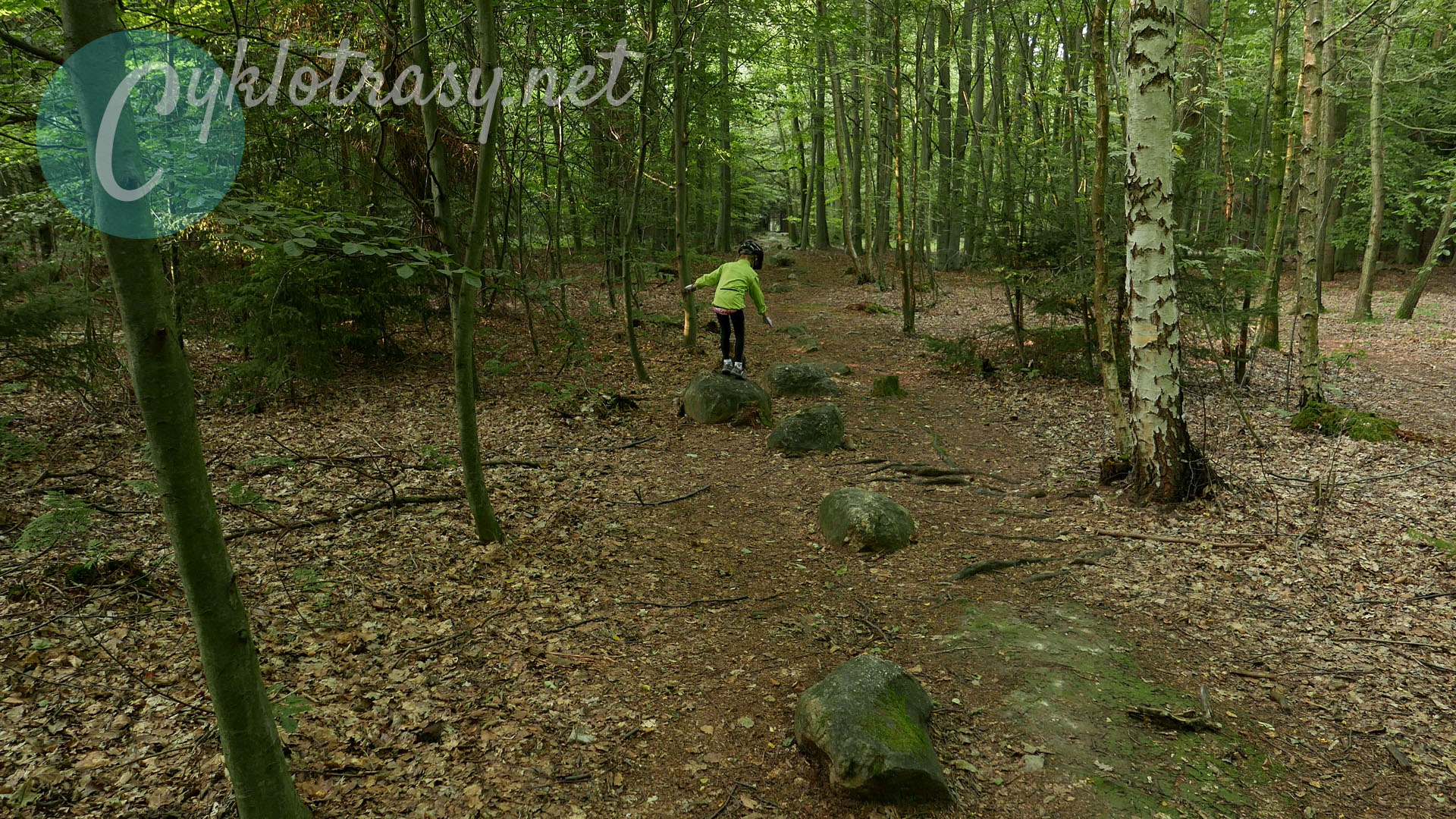
Singletrack through the valley of Pnětluky brook
We will continue the blue back to Konětopy. The downhill ride to the Pnětluky brook valley is beautiful, especially its beginning,
leading through the ravine among the opoka rocks. There is also a nice view of the Ore Mountains, the Central Bohemian Mountains and the
first two table mountains over which we went today - Okrouhlík and Výrov. The footpath along the Pnětluky stream and over the flooded meadow
to Konětopy is perfect. Classic singletrack with field obstacles. It's an wonderful experience, you would not have underwent this on the asphalt
cycle paths.
Poor villages and beautiful countryside
You have to go through the Konětopy and then go around Okrouhlík and cross the Hořany to Zbrašín along the forest road.
At the entrance to Konětopy, in the glow of the setting sun, you can not miss the sad state of the stone houses. We recall what one
of our local people told us when we refreshed at the Pod Borem pub: "The pubs are not here, because the few locals aren't enough to make
them alive. And the tourists are not here. What would they do here? There is nothing here. Not even those pubs. "
But maybe that's the reason why you can come out here. The landscape is mysteriously magical, the trail runs along forest paths
and footpaths with a natural surface and mainly off the roads, except few short parts. All day, we meet only a few mushroom pickers
and tourists, and the region looks like undiscovered from cyclists. And it's just an hour's drive from Prague. And those views of the
Central Bohemian Mountains, they are just great! Just take enough food and drink with you, or you will die miserably.
Refreshments on the way:
Konětopy - Pod Borem pub and Vietnamese shop, Domoušice - U Marušky pub? and Pod Pravdou?
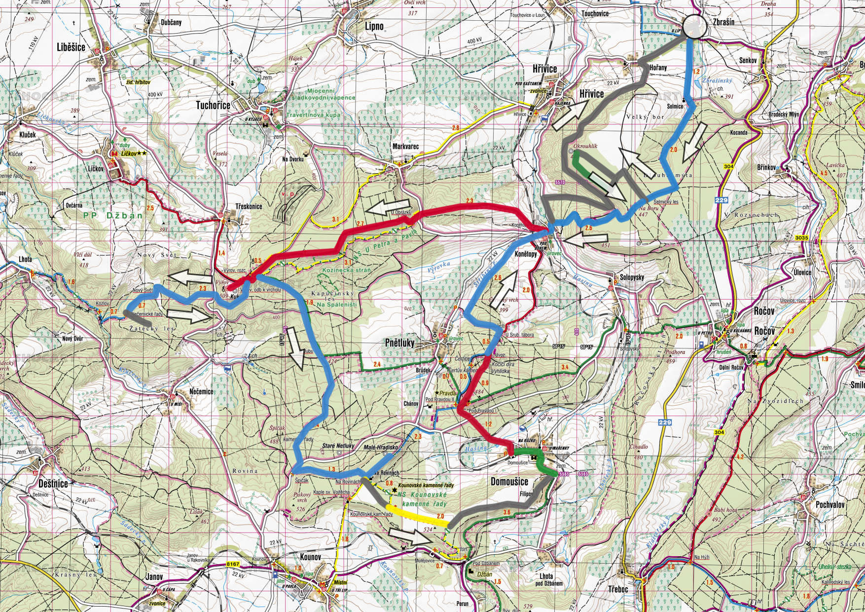
Route:
From Zbrašín on blue through Selmice to the plateau of Okrouhlík - from the crossing Selmický les (Selmice forest) right after the
unmarked forest road to Hradiště Okrouhlík (Hřivice) - after green back to blue - from the crossing with blue along blue to Konětopy -
along the red over the Markvarec Plain to Výrov – along the blue through the New World to Nečice Stone Rows - by the blue back to Výrov
crossroad - along the blue to the Rovina fortification - along the yellow to the Kounov Stone Rows - from the Zadní Rovina along the field
road to Domoušice - the red to the Pravda Castle - along the red and blue to the valley and along the Pnětluky brook to Konětopy - 500 m
along the road in the direction of Hřivice – turn right and through the valley uphill 1,300 m, from the crossroads to the left and around
the hill Okrouhlík along the forest way to Hořany - 1 km on the road to Zbrašín or through the hop field along the field road
 The abandoned landscape northwest of Prague reminds of the Lost World with table-topped mountains. The dinosaurs, unlike Doyle's novel,
do not live here, but the trace of prehistoric people and our recent ancestors has been found here. From the older stone age comes the
finding of a stone chopper from Mutějovice, the unknown age is the head of the celtic warrior and the mysterious Nečice and Kounov
stone rows. On the flat hills there are remains of fortified villages, inhabited for thousands of years, and medieval villages
with stone houses from the local opoka are hidden in the valleys. And cyclists do not touch a living soul in dense forests all day long.
The abandoned landscape northwest of Prague reminds of the Lost World with table-topped mountains. The dinosaurs, unlike Doyle's novel,
do not live here, but the trace of prehistoric people and our recent ancestors has been found here. From the older stone age comes the
finding of a stone chopper from Mutějovice, the unknown age is the head of the celtic warrior and the mysterious Nečice and Kounov
stone rows. On the flat hills there are remains of fortified villages, inhabited for thousands of years, and medieval villages
with stone houses from the local opoka are hidden in the valleys. And cyclists do not touch a living soul in dense forests all day long. 


 Length: 50km